Guatemala
Tikal
The ruins of Tikal are situated in the jungle in Guatemala and are one of the largest archaeological sites and urban centres of the Maya civilization. At its height it was one of the most important Maya cities and dominated much of the Maya world politically, economically, and militarily. Prospering through intensive agricultural it was able to maintain an estimated population as high as 90,000.
The name Tikal is relatively modern being adopted shortly after its discovery in the 1840s and comes from the word Ti akal, meaning "At the Reservoir. Its original name is believed to have been Yax Mutal which means Place of Whispers.
Tikal dates from at least 800 BC and it is known that significant construction was taking place around 400300 BC which included the building of pyramids. During the 1st century AD it started to develop into one of the most influential cities in the region and became one of the most powerful kingdoms of the ancient Maya reaching its peak during the Classic Period (200 to 900 AD).
Tikal was to become a dominant force during the reign of Yikin Chan Kawill following the defeat of Calakmul in 736 AD, and the subsequent defeat of its allies in the following years. This resulted in significant building being carried out to celebrate the victory resulting in it becoming one of the largest of the Classic Maya cities even though it had no water other than what was collected from rainwater and stored in ten reservoirs.
Tikal collapsed started at the end of the ninth century although the reason for its collapsed is not known; War, revolt, disease, natural catastrophe and drought have all been suggested. Drought is certainly a possibility as it was reliant on seasonal rainfall which left it vulnerable to prolonged drought, which is thought to have had a significant influence in the collapse of the Maya. Evidence has been found that some of the buildings were burned, and of a gradual decline in its population resulting in its abandonment by the end of the 10th century.
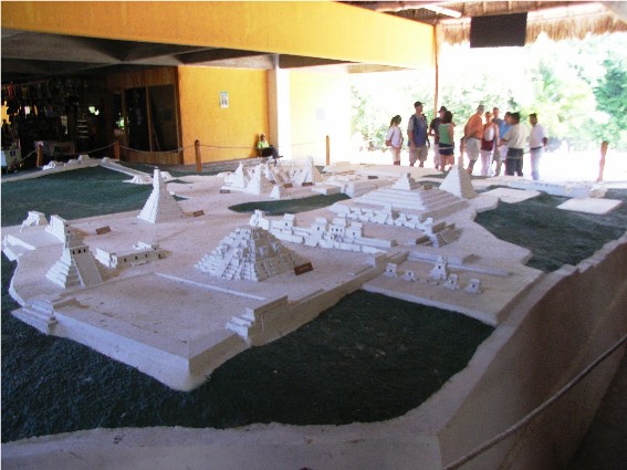
After Tikal was abandoned and overgrown by the jungle, the city remained unknown to outsiders for several centuries. In 1525, Spanish conquistador Hernando Cortés passed near to the ruins but did not learn of them. The first official expedition to Tikal was in 1848 but it wasnt until the 1960s that major excavation work started. Today, many ruins are still covered by jungle. It is estimated that Tikal covers 23 square miles, much of which has not yet been cleared or excavated. Over 4000 structures, which include temples, palaces, pyramids, residences, ballgame courts and inscribed stone monuments have been found. The oldest of these dates back to 800 BC, while the most recent from 900 AD. A set of earthworks has been discovered which surrounds Tikal with a rampart and a 6 meter wide trench.
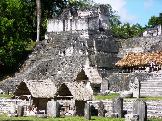
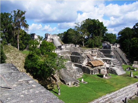
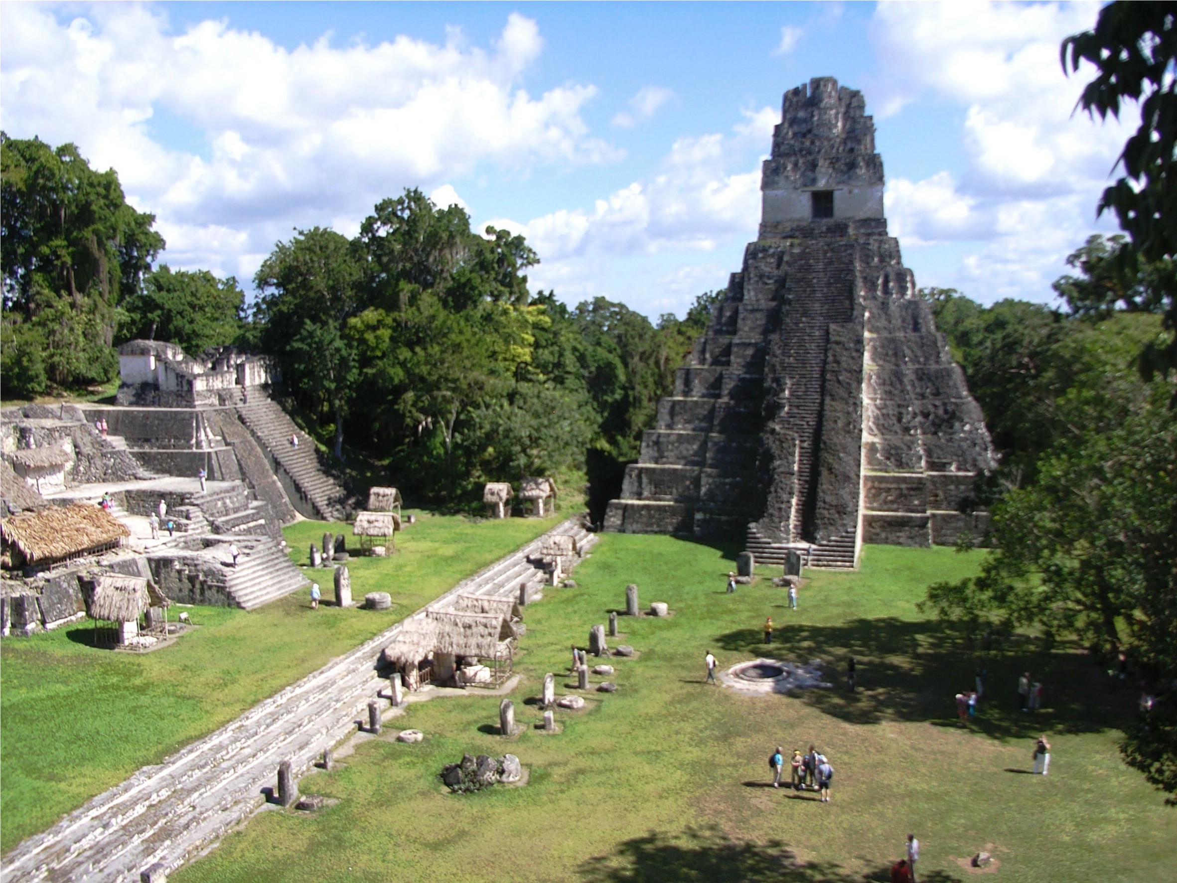
At the heart of Tikal is the Great Plaza which is surrounded by stelae and sculpted altars, ceremonial buildings, residential and administrative palaces, and a ball court. At one end of the plaza rising 154 feet (47 metres) is Temple 1, the Temple of the Great Jaguar a funerary pyramid of Jasaw Chan Kawil, who was entombed there in 734 AD.
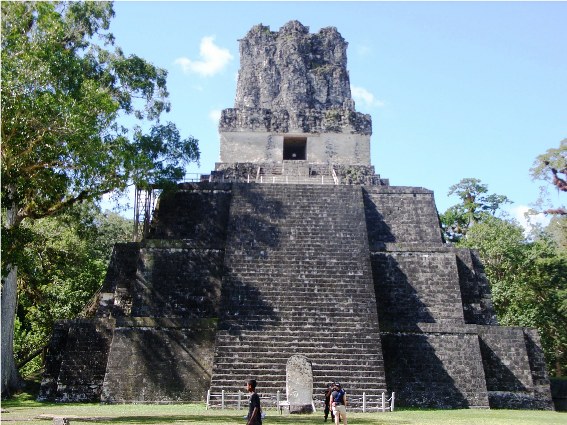
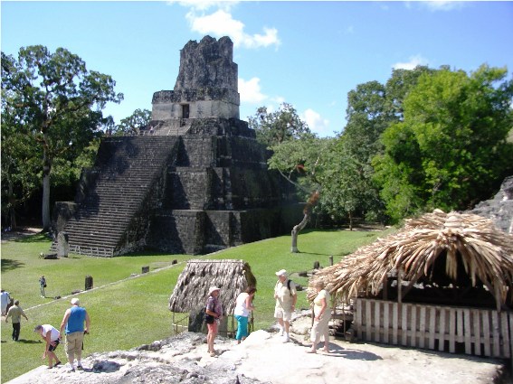
Directly across the Plaza is Temple II, the Temple of the Mask, this was built around 700 AD, the first temple to be completed by Jasaw Chan Kawil it stands 125 feet (38 metres) high. It is believed that it was dedicated to the wife of Jasaw Chan Kawil, although no tomb was found it contains three consecutive chambers at the summit which is normal for temples.
At the north side of the plaza is the North Acropolis, a complex begun around 350 BC and which was to develop into a funerary complex for the ruling dynasty. It has been suggested that the North Acropolis had 70 stelae. Stelae would be carved with hieroglyphic texts and painted red; each stele would have had a commemorative altar beside it. The last dated stele at Tikal was erected in 869 AD.
To the south of the Great Plaza is the palace complex of the Central Acropolis which consists of 45 structures; these include palaces, administrative buildings and patios which were probably used by the royal court. An acropolis is a large royal palace or construction consisting of a number of chambers on different levels. Located around the plaza are the structures of the nobles, smaller temples, and individual shrines, further out are the homes of the common people. Buildings were constructed of locally quarried limestone with the excavations being waterproofed and used as reservoirs. Plazas were laid to a fall to allow the water to be channelled into a system of canals to feed the reservoirs.
The site contains a number of other pyramid temples, which are numbered sequentially during the original survey of the site. Located to the west of the Great Plaza is Temple III, the 180 feet (55 metres) high temple of the Great Priest which was the last of the great pyramid temples constructed in Tikal. Built around 810 AD, it has a carved lintel depicting a person clothed in a jaguar skin and has the finest roof comb of all Maya temples. The tallest temple in Tikal is Temple IV, the Temple of the Double Headed Serpent; it stands 230 feet (70 m) high and is the largest Maya pyramid. It was built by Jasaw Chan Kawils son Yikin Chan Kawil and is built to commemorate his father in 740 AD.
Part of Guatemala's Tikal National Park the ruins were declared a UNESCO World Heritage Site in 1979 and are undergoing excavation and conservation work.