Temples of Angkor Thom & Angkor Wat History, Architecture & Significance
Summary
Angkor consists of two parts, Angkor Thom, which is the city and the temple complex of Angkor Wat. The site is one of the largest and most important archaeological sites in South-East Asia and incorporates many magnificent temples build in the time of the Khmer empire.
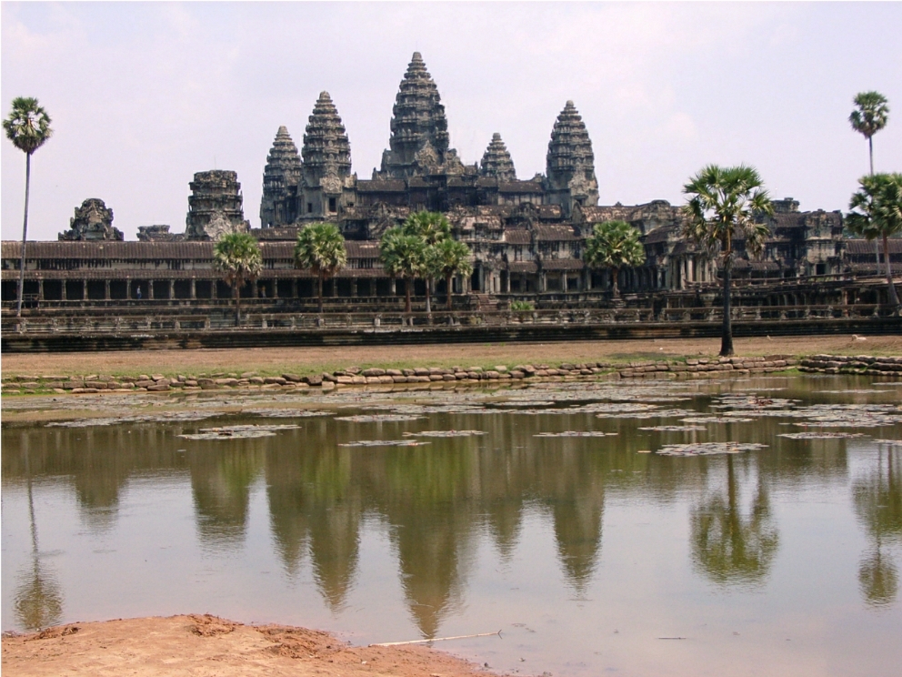
Angkor consists of two parts, Angkor Thom, which is the city and Angkor Wat which is the temple complex. It is the largest religious complex in the world and is the best-preserved example of Khmer architecture in Cambodia.
The site is a vast temple complex near Siem Reap, Cambodia, about 200 miles from the capital of Phnom Penh. Angkor Wat (which means Holy Temple) was built by King Suryavarman II (1113 - 1145 AD) as a vast funerary temple dedicated to the god Vishnu. Suryavarman united the kingdom, following a period of conflict, and conquered many of the surrounding kingdoms, which included the present-day Thailand and an area stretching to Burma, the Malay Peninsula and Laos. It is believed that he died during a military expedition against the Vietnamese Kingdom of Champa.
In 1177 the Champa were responsible for sacking Angkor and in 1181 King Jayavarman VII (1122-1219) invaded Champa and made it part of the Khmer empire, turning the Empire into one of the most prosperous and sophisticated kingdoms in the history of Southeast Asia. Its prosperity resulted in the construction of a wide range of architecture under Jayavarman, who was one of historys great builders and it was he who started the construction of Angkor Thom (meaning Great City) which was to covers over 400 square kilometres.
During its six centuries as the imperial capital, Angkor went through many changes in architectural styles and in religion. The city of Angkor changed from the Hindu God Shiva to Vishnu, and finally to the Mahayana Buddhist Deity Avalokitesvara; all of which had a major influence on its temple architecture. The design of the temples was based on Hindu cosmology, having been built around a central temple situated on a hill. This symbolized Mount Meru, the home of the Gods, with the central tower of each temple representing Mount Meru. The outer walls of the temple represented the mountains that were believed to encircle the cosmos.
The city of Angkor Thom has five gates with the most famous being the South Gate. This has been restored and depicts a number of heads, although these are mostly copies. The causeway leading to the gate has a line of giant statues on either side, although many of these are also copies.
The complex contains many giant faces built of Sandstone which was the main material employed by the Khmers. The stone was cut into huge blocks which are fitted together with great accuracy without the use of cement.
One of the most famous temples is the Bayon. Built in the late 12th or early 13th century as the state temple of King Jayavarman VII and represents Mount Meru the Bayon temple is located at the heart of the city. Dedicated to Buddha, the temple was originally called Jayagiri (which means Victory Mountain) but was renamed Banyan Temple sometime after the French occupied the country in 1863. Subsequently the name was changed to Bayon due to the difficulty that the locals had in pronouncing Banyan. Originally a Hindu temple it was to become a Buddhist temple following the conversion of the Khmer to Buddhism as the state religion in the 13th Century.
The Bayon incorporates towers and contains the faces of the Mahayana Buddhist Deity Avalokitesvara.
Situated close to the Bayon is the Royal Palace built by Jayavarman VII. This was built in several sections which also contained buildings to accommodate the Kings wives and concubines, the palace guards and the priests, although these buildings were constructed of perishable materials so are no longer in existence. The complex was surrounded by a wall of which only the base remains.
At the centre of the Palace Complex is the three stepped pyramid Phimeanakas Temple. This dates from before the palace and was built between 950 and 1050. The name Phimeanakas means Celestial Palace and was used by the king as a private temple.
Next to the temple are the Royal Ponds with sculptures along their 140-metre length. It is believed that these were used for bathing or nautical type events.
On the Eastern side of the Palace enclosure are the Royal Terraces which stretch for 400 metres by the side of the parade grounds.
The Terrace of the Elephants, named due to the heads of elephants protruding from the wall. This was where the Royal family would stage entertainment, and ministers and Generals would review their forces on the parade ground.
To the north of the terrace of the Elephants is the terrace of the Lepper King constructed by Jayavarman VII, although its name derives from a 15th-century sculpture discovered at the site. A copy of which is on the terrace and depicts the Hindu god Yama, the god of death. The walls contains deeply carved reliefs arranged in tiers.
Numerous other reliefs can be seen around the site depict such as events as the Khmer army battling with the Chams.
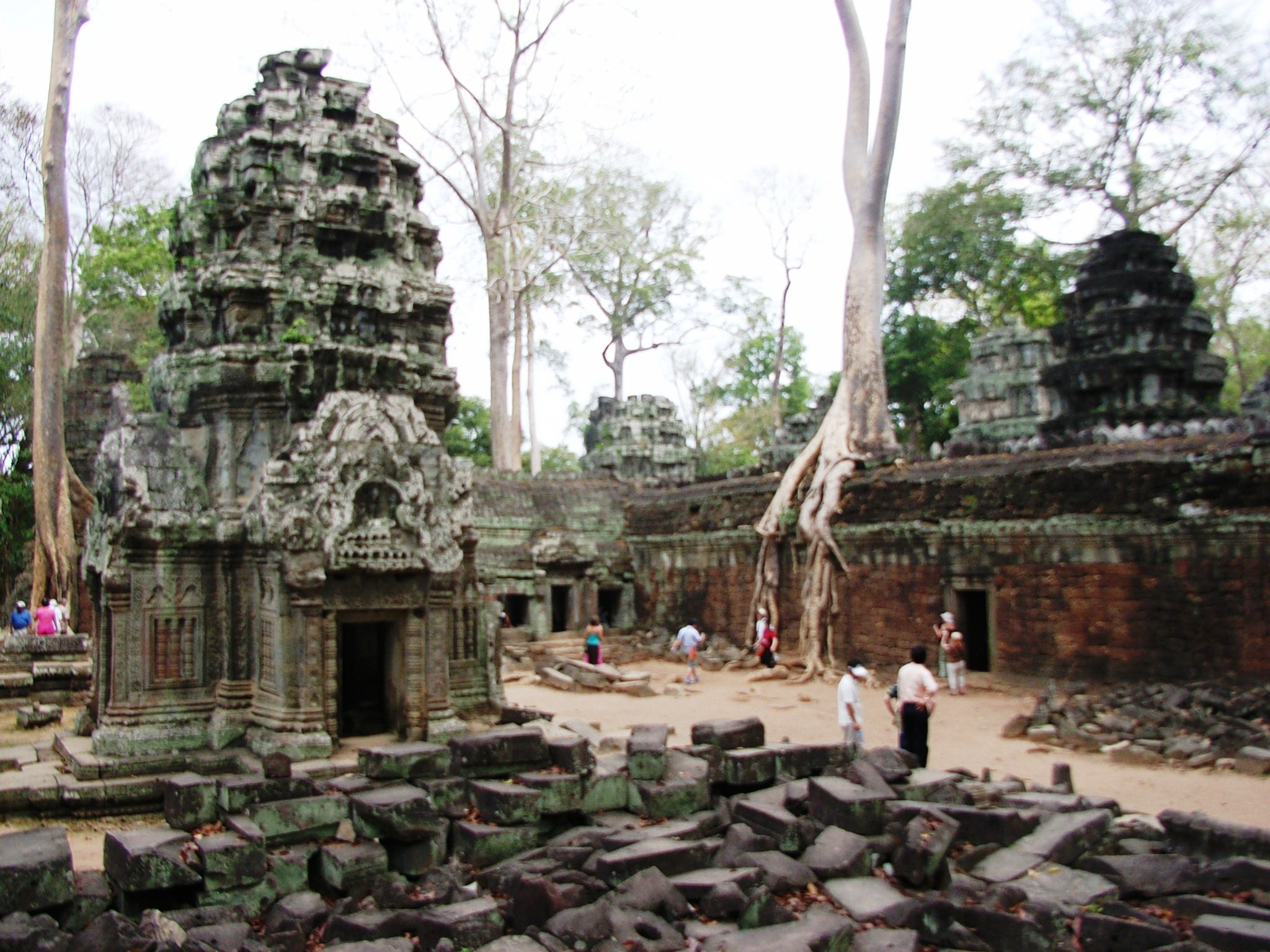
Ta Prohm Temple is renowned for the trees growing from its walls. Where necessary some of the roots have been removed in the interest of preserving the building but in many case the roots themselves stabilise the building. Ta Prohm is also known for the location used in one of the scenes in the film Tomb Raider staring Angelina Jollie.
The success of the Khmer is due in part to its ability to create effective irrigation systems both supplying water to the population and in providing irrigation, although it also symbolised the waters of the cosmos. The system consisted of waterways, canals and moats and a number of large reservoirs.
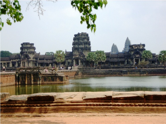
The temple of Angkor Wat consists of five central shrines and courtyards. encircled by a moat. Entry is gained via a paved causeway, leading over the moat and under a portico.
The causeway then continues for a distance of a quarter of a mile between two buildings which are named libraries, although it is not known the purpose of these buildings.
The causeway then leads on to the main entrance of the building with its three galleries.
The galleries are all beautifully decorated with apsaras (heavenly nymphs), together with dancing male figures and animals.
Temples are decorated with bas-reliefs, depicting scenes from the Hindu sacred texts that recount the adventures of two major incarnations of Vishnu. They consist of Gods, men and animals. Angkor contains the worlds longest relief which stretches for 1,200 metres showing bas-reliefs carved into the stone and incorporating over 11,000 figures.
Once into the inner courtyard visitors are able to ascend the steep stairs up to the central shrines.
Angkor flourished from the 9th to the 15th century. At its peak, between the 11th -13th century, it was one of the largest cities in the world, with a population of in the region of 80 150,000. (London at that time had a population of 30,000). 12,000 people served the temple, but its prosperity was to end in 1431 when it was sacked by the Siamese, resulting in the capital being moved to Phnom Penh and Angkor being abandoned and becoming overgrown by the jungle. The process of reclaiming Angkor from the jungle was begun in the 1860s by the French, but the task had to be suspended in the 1970s during the rule of Pol Pot. It was declared a UNESCO World Heritage Site in 1992.
To see more photographs and take a virtual tour of the site click on the videos below.